UN
348 Marsh Lane
£ 82,000
Description
We don't have a Description for this property.
- Bedrooms
- 3
- Bathrooms
- 0

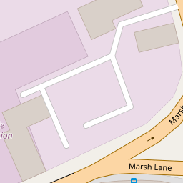

Leaflet © OpenStreetMap contributors
The heatmap indicates the level of crime in the area. The color of the heatmap indicates the crime severity and recency.
Metrics Year-on-Year
- Average area value
- 172,617.00 £Decreased by 13.74 %
- Average area rental value
- 835.00 £/moIncreased by 18.61 %
- Est rental Yield
- 5.80 %Increased by 37.44 %
- Crime Rate
- 5.00 %Unchanged by 0.00 %
from 200,116.00 £
from 704.00 £/mo
from 4.22 %
from 5.00 %
Nearby Schools
| Name | Type | Ofsted | Distance |
|---|---|---|---|
| Christ Church Church Of England Controlled Primary School | Voluntary Controlled School | Good | 0.36 KM |
| Greenacre Community Nursery School | Local Authority Nursery School | Good | 0.67 KM |
| Linacre Primary School | Community School | Requires improvement | 0.81 KM |
| King'S Leadership Academy Hawthornes | Free Schools | Requires improvement | 0.82 KM |
| St Monica'S Catholic Primary School | Voluntary Aided School | Outstanding | 0.91 KM |
Images
Nearby Streets
| Name | Average Price | Average Sqft | Distance |
|---|---|---|---|
| Essex Way | £ 0 | 0 | 0.00 KM |
| Waterworks Street | £ 185,000 | 0 | 0.00 KM |
| Oak Street | £ 0 | 0 | 0.00 KM |
| Litherland Road | £ 0 | 0 | 0.00 KM |
| Menai Road | £ 0 | 0 | 0.00 KM |
Nearby Transport
| Name | NLC | TLC | Distance |
|---|---|---|---|
| Bootle New Strand | 2195 | BNW | 1.18 KM |
| Bootle Oriel Road | 2239 | BOT | 1.63 KM |
| Kirkdale | 2245 | KKD | 1.73 KM |
| Walton (Merseyside) | 2251 | WAO | 2.06 KM |
| Bank Hall | 2238 | BAH | 2.09 KM |
Nearby Listings
| Address | Price | Type | Score | Distance |
|---|---|---|---|---|
| Rutland Street, Bootle, Merseyside, L20 | £ 75,000 | BUY | 5 / 10 | 0.03 KM |
| Rutland Street, Bootle | £ 110,000 | BUY | Unknown | 0.03 KM |
| Rutland Street, Bootle, Merseyside, L20 | £ 110,000 | BUY | 6 / 10 | 0.03 KM |
| Rutland Street, Bootle, Merseyside, L20 | £ 100,000 | BUY | Unknown | 0.03 KM |
| Suffolk Street, Bootle | £ 130,000 | BUY | 6 / 10 | 0.11 KM |
Nearby Properties
| Address | Price | Distance |
|---|---|---|
| 350a Marsh Lane | £ 52,888 | 0.00 KM |
| 354 Marsh Lane | £ 95,000 | 0.00 KM |
| 368 Marsh Lane | £ 60,000 | 0.00 KM |
| 348 Marsh Lane | £ 82,000 | 0.00 KM |
| 360 Marsh Lane | £ 76,000 | 0.00 KM |