UN
4 Grangeside
£ 130,000
Description
We don't have a Description for this property.
- Bedrooms
- 2
- Bathrooms
- 0
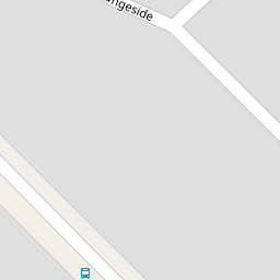

Leaflet © OpenStreetMap contributors
The heatmap indicates the level of crime in the area. The color of the heatmap indicates the crime severity and recency.
Metrics Year-on-Year
- Average area value
- 375,239.00 £Decreased by 6.08 %
- Average area rental value
- 1,067.00 £/moDecreased by 13.74 %
- Est rental Yield
- 3.41 %Decreased by 8.33 %
- Crime Rate
- 2.00 %Unchanged by 0.00 %
from 399,544.00 £
from 1,237.00 £/mo
from 3.72 %
from 2.00 %
Nearby Schools
| Name | Type | Ofsted | Distance |
|---|---|---|---|
| Hope School | Community Special School | Outstanding | 0.50 KM |
| Our Lady Of The Assumption Catholic Primary School | Voluntary Aided School | Good | 0.72 KM |
| Belle Vale & Hunts Cross Children'S Centre | Children's Centre | 0.80 KM | |
| Gateacre School | Community School | Requires improvement | 0.94 KM |
| Childwall Valley Primary School | Community School | Good | 1.01 KM |
Images
Nearby Streets
| Name | Average Price | Average Sqft | Distance |
|---|---|---|---|
| Highfield Drive | £ 392,475 | 0 | 0.00 KM |
| Hathaway Road | £ 282,500 | 0 | 0.00 KM |
| Fieldfare Close | £ 327,500 | 0 | 0.00 KM |
| Station Road | £ 296,000 | 0 | 0.00 KM |
| Dunnock Close | £ 562,500 | 0 | 0.00 KM |
Nearby Transport
| Name | NLC | TLC | Distance |
|---|---|---|---|
| Roby | 2261 | ROB | 2.80 KM |
| Hunts Cross | 2235 | HNX | 3.33 KM |
| Broad Green | 2240 | BGE | 3.46 KM |
| Huyton | 2160 | HUY | 3.69 KM |
| Liverpool South Parkway | 9709 | LPY | 4.08 KM |
Nearby Listings
| Address | Price | Type | Score | Distance |
|---|---|---|---|---|
| Grange Way, Woolton, L25 | £ 325,000 | BUY | 8 / 10 | 0.14 KM |
| Mountfield Crescent, Gateacre, Liverpool, Merseyside, L25 | £ 325,000 | BUY | 6 / 10 | 0.16 KM |
| Grange Lane, Gateacre, Liverpool, L25 | £ 325,000 | BUY | 6 / 10 | 0.16 KM |
| Mountfield Crescent, Liverpool, L25 | £ 390,000 | BUY | Unknown | 0.17 KM |
| Mountfield Crescent, Liverpool, L25 | £ 350,000 | BUY | 6 / 10 | 0.17 KM |
Nearby Properties
| Address | Price | Distance |
|---|---|---|
| 8 Grangeside | £ 165,000 | 0.00 KM |
| 10 Grangeside | £ 157,950 | 0.00 KM |
| 36 Grangeside | £ 175,000 | 0.00 KM |
| 30 Grangeside | £ 175,000 | 0.00 KM |
| 38 Grangeside | £ 372,800 | 0.00 KM |