UN
12 Cunningham Road
£ 124,500
Description
We don't have a Description for this property.
- Bedrooms
- 3
- Bathrooms
- 0
- Sqft
- 947.00
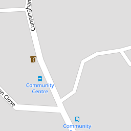

Leaflet © OpenStreetMap contributors
The heatmap indicates the level of crime in the area. The color of the heatmap indicates the crime severity and recency.
Metrics Year-on-Year
- Average area value
- 292,494.00 £Increased by 16.53 %
- Est sale value
- 266,107.00 £Increased by 15.16 %
- Average area rental value
- 1,200.00 £/moIncreased by 6.76 %
- Est letting value
- 947.00 £/moUnchanged by 0.00 %
- Est rental Yield
- 4.92 %Decreased by 8.38 %
- Crime Rate
- 25.00 %Unchanged by 0.00 %
from 250,997.00 £
from 231,068.00 £
from 1,124.00 £/mo
from 947.00 £/mo
from 5.37 %
from 25.00 %
Nearby Schools
| Name | Type | Ofsted | Distance |
|---|---|---|---|
| Mary Dean'S Cofe Primary School | Voluntary Controlled School | Good | 0.38 KM |
| Woodfield Primary School | Academy Converter | Good | 1.63 KM |
| St Peter'S Rc Primary School | Academy Converter | Good | 1.68 KM |
| Whitleigh Children'S Centre | Children's Centre | 1.82 KM | |
| Brook Green Centre For Learning | Community Special School | Outstanding | 2.04 KM |
Images
Nearby Streets
| Name | Average Price | Average Sqft | Distance |
|---|---|---|---|
| Allern Lane | £ 290,000 | 0 | 0.00 KM |
| Porsham Lane | £ 0 | 0 | 0.00 KM |
| Magnus Close | £ 0 | 0 | 0.00 KM |
| Trowbridge Close | £ 105,000 | 0 | 0.00 KM |
Nearby Transport
| Name | NLC | TLC | Distance |
|---|---|---|---|
| Bere Ferrers | 3550 | BFE | 3.74 KM |
| St Budeaux Victoria Road | 3592 | SBV | 5.40 KM |
| St Budeaux Ferry Road | 3590 | SBF | 5.40 KM |
| Keyham | 3571 | KEY | 5.91 KM |
| Plymouth | 3580 | PLY | 6.44 KM |
Nearby Listings
| Address | Price | Type | Score | Distance |
|---|---|---|---|---|
| Cunningham Road, Plymouth Beautifully Presented Three-Bedroom End-Terrace Home in Sought-After Tamerton Foliot | £ 210,000 | BUY | Unknown | 0.01 KM |
| Cunningham Road, Tamerton Foliot, Plymouth | £ 190,000 | BUY | 7 / 10 | 0.11 KM |
| Cunningham Road, Plymouth | £ 190,000 | BUY | Unknown | 0.11 KM |
| Cunningham Road, Tamerton Foliot, Plymouth, Devon, PL5 | £ 170,000 | BUY | 5 / 10 | 0.11 KM |
| Cunningham Road, Tamerton Foliot, Plymouth | £ 200,000 | BUY | Unknown | 0.14 KM |
Nearby Properties
| Address | Price | Distance |
|---|---|---|
| 60 Cunningham Road | £ 167,500 | 0.00 KM |
| 42 Cunningham Road | £ 63,500 | 0.00 KM |
| 54 Cunningham Road | £ 195,000 | 0.00 KM |
| 27 Cunningham Road | £ 146,000 | 0.00 KM |
| 21 Cunningham Road | £ 125,000 | 0.00 KM |