GO
Bournemouth
By Goadsby
£ 1,150
Goadsby says ..
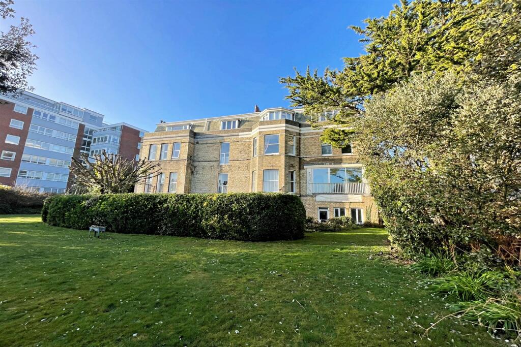
TWO BEDROOM CLIFF TOP FLAT IN DESIRABLE LOCATION WITH SEA VIEWS FROM COMMUNAL GARDENS - Offered unfurnished
- Bedrooms
- 2
- Bathrooms
- 1
The heatmap indicates the level of crime in the area. The color of the heatmap indicates the crime severity and recency.
Metrics Year-on-Year
- Average area value
- 264,167.00 £Decreased by 12.20 %
- Average area rental value
- 1,097.00 £/moDecreased by 17.58 %
- Est rental Yield
- 4.98 %Decreased by 6.21 %
- Crime Rate
- 3.00 %Unchanged by 0.00 %
from 300,857.00 £
from 1,331.00 £/mo
from 5.31 %
from 3.00 %
Agent Activity
Goadsby created the listing.
Nearby Schools
| Name | Type | Ofsted | Distance |
|---|---|---|---|
| Livingstone Academy Bournemouth | Free Schools | 0.99 KM | |
| Malmesbury Park Primary School | Academy Converter | Good | 1.44 KM |
| Bethany Church Of England Junior School | Academy Converter | Requires improvement | 1.61 KM |
| St Clement'S And St John'S Church Of England Infant School | Academy Converter | Good | 1.78 KM |
| Bournemouth Christian School | Other Independent School | Good | 1.94 KM |
Images


Nearby Streets
| Name | Average Price | Average Sqft | Distance |
|---|---|---|---|
| Undercliff Drive | £ 0 | 0 | 0.00 KM |
| Lansdowne Crescent | £ 0 | 0 | 0.00 KM |
| St Pauls Road | £ 0 | 0 | 0.00 KM |
| St Paul's Place | £ 0 | 0 | 0.00 KM |
| Madeira Roundabout | £ 0 | 0 | 0.00 KM |
Nearby Transport
| Name | NLC | TLC | Distance |
|---|---|---|---|
| Bournemouth | 5876 | BMH | 1.06 KM |
| Pokesdown | 5885 | POK | 4.19 KM |
| Branksome | 5875 | BSM | 6.58 KM |
| Christchurch | 5879 | CHR | 8.72 KM |
| Parkstone (Dorset) | 5882 | PKS | 9.64 KM |
Nearby Listings
| Address | Price | Type | Score | Distance |
|---|---|---|---|---|
| Bournemouth | £ 1,225 | RENT | Unknown | 0.11 KM |
| Athelney Court, Bournemouth, BH1 | £ 1,250 | RENT | Unknown | 0.16 KM |
| Grove Road, Bournemouth, BH1 | £ 1,400 | RENT | Unknown | 0.18 KM |
| Flat 7 Grosvenor Court | £ 1,200 | RENT | Unknown | 0.18 KM |
| Grove Road, Bournemouth, BH1 | £ 1,450 | RENT | Unknown | 0.22 KM |
Nearby Properties
| Address | Price | Distance |
|---|---|---|
| 65 Grove Road | £ 315,000 | 0.17 KM |
| 16 Grove Road | £ 475,000 | 0.18 KM |
| 30 Grove Road | £ 200,000 | 0.18 KM |
| 37 Gervis Road | £ 830,000 | 0.26 KM |
| 17 Gervis Road | £ 105,000 | 0.26 KM |