Swallow Drive, Wymondham, Norfolk, NR18
By Abbotts
£ 450,000
Reviews
4 out of 5 stars
Abbotts says ..
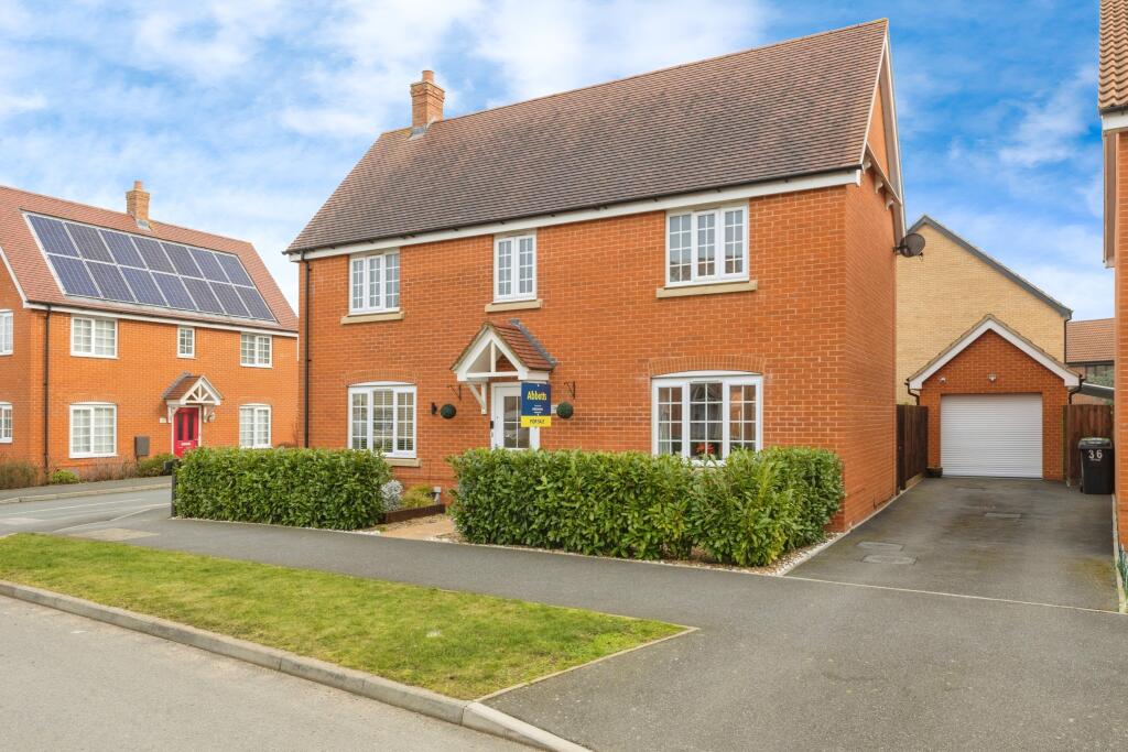
Stunning Executive Family Home in a Prime Location Built in 2019 by renowned developer Taylor Wimpey, this immaculately presented, executive-style family home offers the perfect blend of modern living and comfort. From the moment you step through the front door, you’re welcomed i...
Property Oracle says ..
The property is a 4-bedroom, 2-bathroom house with a total area of 1,202.17 sqft and a plot size of 1,521 sqft. The list price is £450,000. The property appears to be in excellent condition. The images show a modern, well-maintained interior and exterior. The kitchen and bathrooms look recently updated, and the overall presentation is high-quality. The garden is well-maintained and offers a pleasant outdoor space. The location in South Wymondham benefits from proximity to several schools, with Browick Road Primary and Nursery School (Outstanding Ofsted rating) being relatively close. Wymondham High Academy (Good Ofsted rating) is also within a reasonable distance. The presence of a nearby train station (Wymondham) adds to the convenience of the location. Considering the average price per sqft in the area is £290, and this property is listed at £450,000 for 1,202.17 sqft, the price per sqft is approximately £374. While this is higher than the average, the property’s superior condition, larger plot size, and proximity to amenities may justify the premium. However, a direct comparison with similarly sized and styled properties in the area would be beneficial to fully assess the price’s reasonableness. Nearby comparable properties are lacking sufficient data to fully analyze.
Therefore, we give this property 8 / 10. *Disclaimer: This is our option and does constitute a recommendation or financial advice. Do your own research. *
- Price
- 7
- Condition
- 9
- Location
- 8
- Land
- 8
- Bedrooms
- 4
- Bathrooms
- 2
- Sqft (est)
- 1,202.17
- Lot (est)
- 1,521.00
The heatmap indicates the level of crime in the area. The color of the heatmap indicates the crime severity and recency.
Metrics Year-on-Year
- Average area value
- 420,000.00 £Increased by 28.91 %
- Est sale value
- 837,912.49 £Increased by 120.57 %
- Average area rental value
- 1,400.00 £/moIncreased by 9.12 %
- Est letting value
- 2,404.34 £/moIncreased by 100.00 %
- Est rental Yield
- 4.00 %Decreased by 15.43 %
- Crime Rate
- 32.00 %Unchanged by 0.00 %
Agent Activity
Abbotts created the listing.
Nearby Schools
| Name | Type | Ofsted | Distance |
|---|---|---|---|
| Browick Road Primary And Nursery School | Community School | Outstanding | 1.61 KM |
| Wymondham High Academy | Academy Converter | Good | 2.15 KM |
| Ashleigh Primary School And Nursery, Wymondham | Community School | Outstanding | 2.54 KM |
| Robert Kett Primary School | Foundation School | Requires improvement | 2.61 KM |
| Wymondham Area Children'S Centre | Children's Centre | 2.62 KM |
Images


Nearby Streets
| Name | Average Price | Average Sqft | Distance |
|---|---|---|---|
| Lark Lane | £ 0 | 0 | 0.00 KM |
| Monarch Close | £ 0 | 0 | 0.00 KM |
Nearby Transport
| Name | NLC | TLC | Distance |
|---|---|---|---|
| Wymondham | 7383 | WMD | 1.16 KM |
| Spooner Row | 7379 | SPN | 4.89 KM |
Nearby Listings
| Address | Price | Type | Score | Distance |
|---|---|---|---|---|
| Swallow Drive, Wymondham, Norfolk, NR18 | £ 450,000 | BUY | 8 / 10 | 0.00 KM |
| Swallow Drive, Wymondham, NR18 | £ 425,000 | BUY | 7 / 10 | 0.03 KM |
| Swallow Drive, Wymondham | £ 450,000 | BUY | Unknown | 0.03 KM |
| Magpie Place, Wymondham, Norfolk, NR18 | £ 230,000 | BUY | Unknown | 0.04 KM |
| Magpie Place, Wymondham | £ 220,000 | BUY | 7 / 10 | 0.08 KM |
Nearby Properties
| Address | Price | Distance |
|---|---|---|
| Colls Farm | £ 500,000 | 0.37 KM |
| Park House | £ 119,254 | 0.41 KM |
| 94 Silfield Road | £ 196,000 | 0.41 KM |
| 86 Silfield Road | £ 185,000 | 0.41 KM |
| 80 Silfield Road | £ 305,000 | 0.41 KM |