
Plot 6 The Regent, Pendle Farm, Worsthorne
By The Agency UK
£ 285,000
Reviews
4 out of 5 stars
The Agency UK says ..
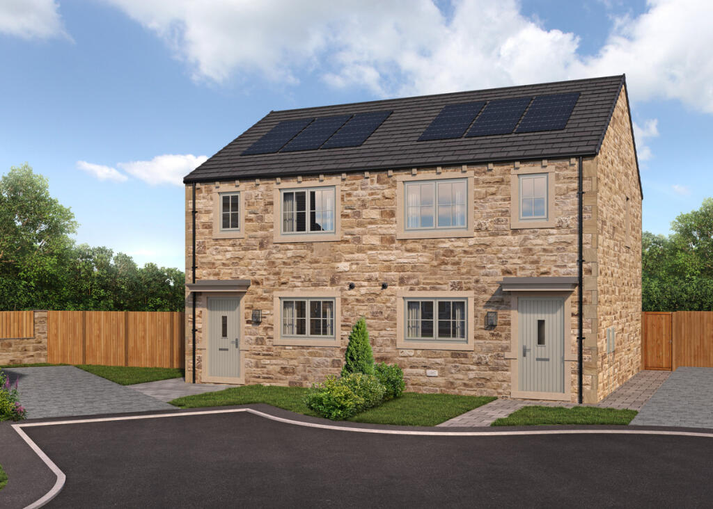
SALES OFFICE NOW OPEN - A NATURAL STONE home with SOLAR PANELS, in an idyllic VILLAGE. A spacious FAMILY-friendly layout with COZY lounge and PATIO DOORS
Property Oracle says ..
Plot 6 The Regent, Pendle Farm, Worsthorne is a 3 bedroom, 2 bathroom semi-detached property located in Cliviger With Worsthorne, Burnley, Lancashire. The property is listed at £285,000 and has a plot size of 850 sqft. The average house price in the area is £309,642, with an average price per sqft of £258. The property appears to be in excellent condition, with modern fixtures and fittings throughout. The images show a well-maintained interior and exterior. The property benefits from a small garden. The location is good, with Worsthorne Primary School being only 0.30 KM away. There are also several other schools within a reasonable distance, as well as train stations in nearby Burnley. Given the property’s condition, location, and the relatively small plot size, the list price of £285,000 appears to be reasonable, especially when compared to the average price per sqft in the area. While the average house price is higher, the smaller size of this property accounts for the lower list price. Nearby comparable properties support this assessment.
Therefore, we give this property 8 / 10. *Disclaimer: This is our option and does constitute a recommendation or financial advice. Do your own research. *
- Price
- 8
- Condition
- 10
- Location
- 8
- Land
- 6
- Bedrooms
- 3
- Bathrooms
- 2
- Sqft (est)
- 732.00
- Lot (est)
- 850.00
The heatmap indicates the level of crime in the area. The color of the heatmap indicates the crime severity and recency.
Metrics Year-on-Year
- Average area value
- 537,450.00 £Increased by 70.34 %
- Est sale value
- 289,872.00 £Increased by 40.43 %
- Average area rental value
- 988.00 £/moIncreased by 30.00 %
- Est letting value
- 0.00 £/mo
- Est rental Yield
- 2.21 %Decreased by 23.53 %
- Crime Rate
- 78.00 %Unchanged by 0.00 %
Agent Activity
The Agency UK marked this listing as sold.
The Agency UK created the listing.
Nearby Schools
| Name | Type | Ofsted | Distance |
|---|---|---|---|
| Worsthorne Primary School | Community School | Good | 0.30 KM |
| Compass Community School Lancashire | Other Independent Special School | 2.65 KM | |
| Burnley Brunshaw Primary School | Community School | Requires improvement | 3.21 KM |
| Briercliffe Primary School | Community School | Good | 3.26 KM |
| Unity College | Foundation School | Good | 3.39 KM |
Images


Nearby Streets
| Name | Average Price | Average Sqft | Distance |
|---|---|---|---|
| Chapel Street | £ 159,950 | 0 | 0.00 KM |
| Hall Street | £ 0 | 0 | 0.00 KM |
| Halstead Street | £ 0 | 0 | 0.00 KM |
| Dawson Drive | £ 0 | 0 | 0.00 KM |
| Deerpark Road | £ 229,950 | 0 | 0.00 KM |
Nearby Transport
| Name | NLC | TLC | Distance |
|---|---|---|---|
| Nelson | 2565 | NEL | 5.91 KM |
| Burnley Central | 2550 | BNC | 5.98 KM |
| Burnley Manchester Road | 2549 | BYM | 6.37 KM |
| Brierfield | 2554 | BRF | 6.49 KM |
| Burnley Barracks | 2743 | BUB | 7.40 KM |
Nearby Listings
| Address | Price | Type | Score | Distance |
|---|---|---|---|---|
| Ormerod Street, Worsthorne, Lancashire, BB10 3NU | £ 265,000 | BUY | 6 / 10 | 0.00 KM |
| Pendle Farm, Worsthorne, BB10 | £ 400,000 | BUY | 7 / 10 | 0.00 KM |
| Plot 22 The Emily, Pendle Farm, Worsthorne | £ 400,000 | BUY | 5 / 10 | 0.00 KM |
| Plot 11 The Berkeley, Pendle Farm, Worsthorne | £ 495,000 | BUY | 6 / 10 | 0.00 KM |
| Plot 29, The Byre Pendle Farm, Worsthorne | £ 315,000 | BUY | 7 / 10 | 0.00 KM |
Nearby Properties
| Address | Price | Distance |
|---|---|---|
| 19 Ormerod Street | £ 250,000 | 0.01 KM |
| 40 Ormerod Street | £ 150,000 | 0.01 KM |
| 20 Ormerod Street | £ 210,000 | 0.01 KM |
| 17 Ormerod Street | £ 165,000 | 0.01 KM |
| 3 Ormerod Street | £ 150,000 | 0.01 KM |