MA
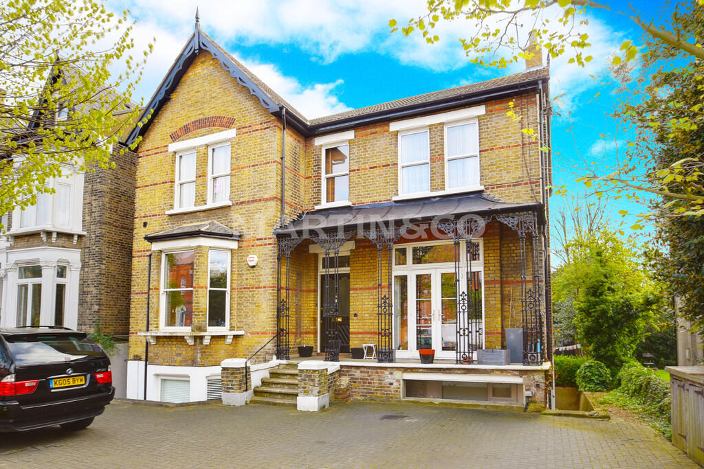
Hermon Hill, Wanstead
By Martin & Co
£ 2,100
Martin & Co says ..
* UNFURNISHED * GROUND FLOOR FLAT, SET WITHIN PERIOD CONVERSION * HERMON HILL * DRIVEWAY PARKING * PRIVATE GARDEN * SPACIOUS KITCHEN WITH APPLIANCES * 2 DOUBLE BEDROOMS * 0.1 MILES TO WANSTEAD HIGH ST * 0.2 MILES TO SNARESBROOK STATION *
- Bedrooms
- 2
- Bathrooms
- 1
The heatmap indicates the level of crime in the area. The color of the heatmap indicates the crime severity and recency.
Metrics Year-on-Year
- Average area value
- 420,625.00 £Decreased by 41.98 %
- Average area rental value
- 1,859.00 £/moDecreased by 4.42 %
- Est rental Yield
- 5.30 %Increased by 64.60 %
- Crime Rate
- 3.00 %Unchanged by 0.00 %
from 724,949.00 £
from 1,945.00 £/mo
from 3.22 %
from 3.00 %
Agent Activity
Martin & Co created the listing.
Nearby Schools
| Name | Type | Ofsted | Distance |
|---|---|---|---|
| Wanstead Church School | Voluntary Aided School | Outstanding | 0.38 KM |
| Snaresbrook Primary School | Community School | Good | 0.41 KM |
| Wanstead Children'S Centre | Children's Centre | 0.49 KM | |
| Our Lady Of Lourdes Rc Primary School | Academy Converter | 1.01 KM | |
| Snaresbrook Prep School | Other Independent School | 1.09 KM |
Images


Nearby Streets
| Name | Average Price | Average Sqft | Distance |
|---|---|---|---|
| Nelson Road | £ 550,000 | 0 | 0.00 KM |
| Eagle Court | £ 0 | 0 | 0.00 KM |
| Esmat Close | £ 0 | 0 | 0.00 KM |
| Sultan Road | £ 0 | 0 | 0.00 KM |
| Mountier Court | £ 0 | 0 | 0.00 KM |
Nearby Transport
| Name | NLC | TLC | Distance |
|---|---|---|---|
| Leytonstone High Road | 7403 | LER | 2.76 KM |
| Wood Street | 6954 | WST | 3.07 KM |
| Wanstead Park | 7408 | WNP | 3.39 KM |
| Forest Gate | 6876 | FOG | 3.64 KM |
| Leyton Midland Road | 7402 | LEM | 3.90 KM |
Nearby Listings
| Address | Price | Type | Score | Distance |
|---|---|---|---|---|
| Hermon Hill, London, E11 | £ 1,500 | RENT | Unknown | 0.00 KM |
| Hermon Hill | £ 1,300 | RENT | Unknown | 0.00 KM |
| Hermon Hill, London, E11 | £ 1,675 | RENT | Unknown | 0.01 KM |
| Hermon Hill, Wanstead | £ 1,550 | RENT | Unknown | 0.09 KM |
| Hermon Hill, Wanstead, E11 | £ 1,225 | RENT | Unknown | 0.11 KM |
Nearby Properties
| Address | Price | Distance |
|---|---|---|
| 37b Hermon Hill | £ 65,000 | 0.00 KM |
| 29a Hermon Hill | £ 168,850 | 0.00 KM |
| 37a Hermon Hill | £ 276,500 | 0.00 KM |
| 11c Hermon Hill | £ 85,000 | 0.00 KM |
| 31b Hermon Hill | £ 196,000 | 0.00 KM |