Lynton Avenue, Orpington
By Thomas Brown Estates
£ 580,000
Reviews
3 out of 5 stars
Thomas Brown Estates says ..
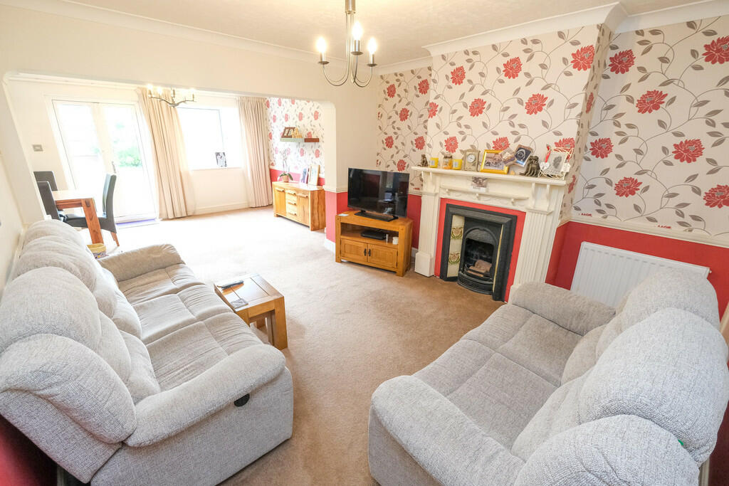
Thomas Brown Estates are delighted to offer this deceptively spacious (1788 SQFT) four bedroom two bathroom side and rear extended semi-detached property boasting large room dimensions, walking distance to St. Mary Cray Station and close to local shops including the popular Nugent Retail Park and...
Property Oracle says ..
The property is a 4-bedroom, 2-bathroom semi-detached house located on Lynton Avenue in Orpington, Bromley.
It has a list price of £580,000 and a plot size of 1,788.30 sqft. The internal area is 1,623.02 sqft.
The property benefits from a good location, being within proximity to several primary schools with good Ofsted ratings. The nearby St Mary Cray train station offers convenient access to Southeastern train services. The property also appears to have a good-sized garden.
Based on the provided images, the property seems to be in generally good condition, although some rooms show signs of needing some cosmetic updates. The kitchen and bathrooms appear functional but could benefit from some modernisation to enhance their appeal.
Considering the average house price in the area is £469,288 and the average price per sqft is £488, the list price of £580,000 for this 1,623.02 sqft property seems slightly on the higher side, especially given that some modernisation may be desirable. However, the larger plot size and the desirable location could justify a premium compared to the average price per sqft. The nearby comparable properties show a range of prices, with some exceeding the list price, suggesting that the property’s asking price is within the range of similar properties in the area.
Therefore, we give this property 7 / 10. *Disclaimer: This is our option and does constitute a recommendation or financial advice. Do your own research. *
- Price
- 6
- Condition
- 7
- Location
- 8
- Land
- 7
- Bedrooms
- 4
- Bathrooms
- 2
- Sqft (est)
- 1,623.02
- Lot (est)
- 1,788.30
The heatmap indicates the level of crime in the area. The color of the heatmap indicates the crime severity and recency.
Metrics Year-on-Year
- Average area value
- 426,250.00 £Increased by 1.76 %
- Est sale value
- 748,212.22 £Decreased by 1.71 %
- Average area rental value
- 1,721.00 £/moDecreased by 0.92 %
- Est letting value
- 1,623.02 £/moUnchanged by 0.00 %
- Est rental Yield
- 4.85 %Decreased by 2.61 %
- Crime Rate
- 5.00 %Unchanged by 0.00 %
Agent Activity
Thomas Brown Estates created the listing.
Nearby Schools
| Name | Type | Ofsted | Distance |
|---|---|---|---|
| Poverest Primary School | Foundation School | Good | 0.69 KM |
| Leesons Primary School | Academy Converter | Good | 0.78 KM |
| St. Mary Cray Primary Academy | Academy Sponsor Led | Good | 0.93 KM |
| Cotmandene Children And Family Centre | Children's Centre | 1.30 KM | |
| St Philomena'S Primary School | Academy Converter | Good | 1.40 KM |
Images


Nearby Streets
| Name | Average Price | Average Sqft | Distance |
|---|---|---|---|
| Oswin Close | £ 0 | 0 | 0.00 KM |
| Oakdene Road | £ 492,500 | 0 | 0.00 KM |
| Leigh Terrace | £ 525,000 | 0 | 0.00 KM |
| St. Andrew's Drive | £ 0 | 0 | 0.00 KM |
| Seven Stiles Court | £ 0 | 0 | 0.00 KM |
Nearby Transport
| Name | NLC | TLC | Distance |
|---|---|---|---|
| St Mary Cray | 5073 | SMY | 0.32 KM |
| Orpington | 5122 | ORP | 2.91 KM |
| Petts Wood | 5123 | PET | 3.66 KM |
| Chelsfield | 5098 | CLD | 3.99 KM |
| Sidcup | 5125 | SID | 4.67 KM |
Nearby Listings
| Address | Price | Type | Score | Distance |
|---|---|---|---|---|
| Lynton Avenue, Orpington | £ 580,000 | BUY | 7 / 10 | 0.00 KM |
| Lynton Avenue, Orpington | £ 740,000 | BUY | 8 / 10 | 0.07 KM |
| Lynton Avenue, Orpington, BR5 | £ 600,000 | BUY | 7 / 10 | 0.07 KM |
| Stanley Way, Orpington, BR5 | £ 350,000 | BUY | 6 / 10 | 0.13 KM |
| Stanley Way, Orpington | £ 260,000 | BUY | Unknown | 0.15 KM |
Nearby Properties
| Address | Price | Distance |
|---|---|---|
| 44 Lynton Avenue | £ 415,000 | 0.07 KM |
| 21 Lynton Avenue | £ 205,000 | 0.07 KM |
| 38 Lynton Avenue | £ 475,000 | 0.07 KM |
| 39 Lynton Avenue | £ 762,000 | 0.07 KM |
| 30 Lynton Avenue | £ 543,000 | 0.07 KM |