
Stourhead Drive, East Hunsbury, Northampton NN4
By O'Riordan Bond
£ 395,000
Reviews
4 out of 5 stars
O'Riordan Bond says ..
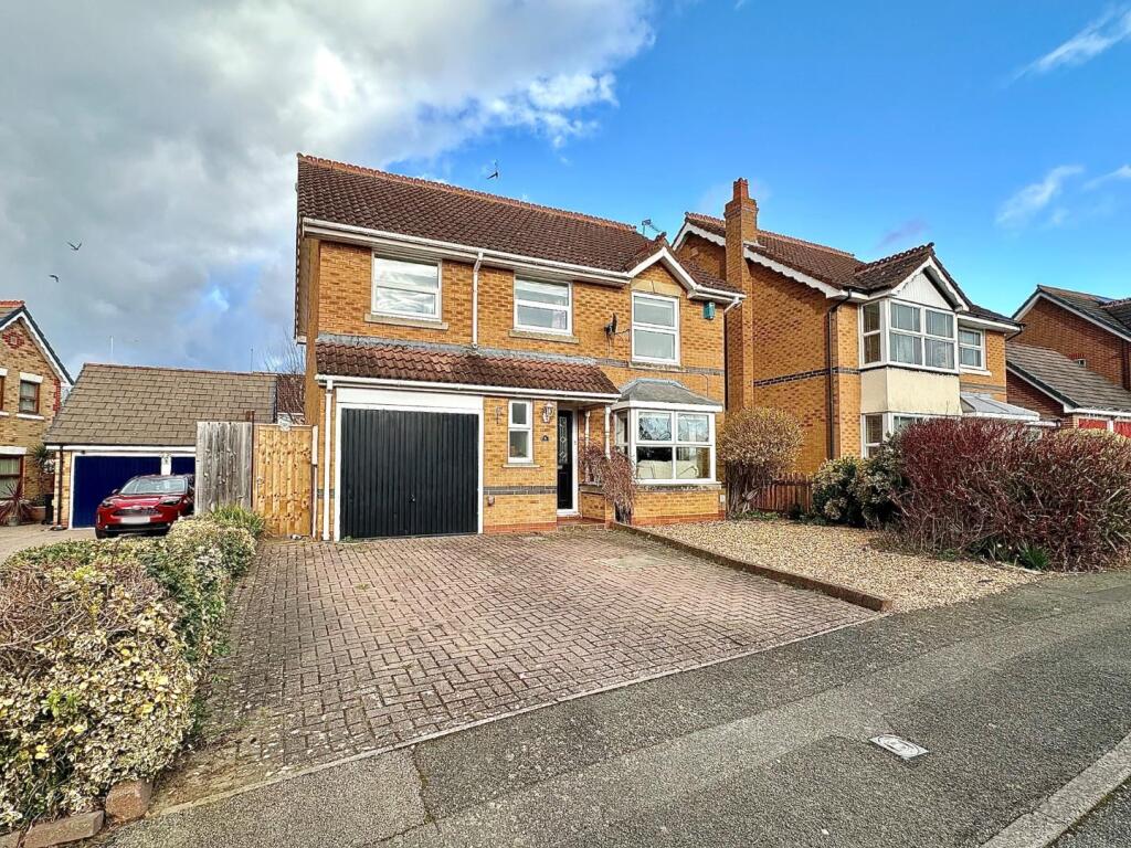
A well presented four bedroom detached family home, situated in a cul-de-sac, within the desirable area of East Hunsbury. This property provides generous accommodation over two floors comprising entrance hall with stairs to the first floor, a cloakroom/WC, good size sitting room with bay window ...
Property Oracle says ..
The property is located in Stourhead Drive, East Hunsbury, Northampton, and is a four-bedroom, two-bathroom detached house with a total area of 3,271 square feet. The plot size is 1,280 square feet. The list price is £395,000. The property is situated within easy reach of several schools, including Wootton Park School (Outstanding Ofsted rating) which is less than a kilometer away. The proximity to good schools is a positive factor for families. Northampton train station is approximately 3.39 km away, providing access to rail transportation. Based on the provided images, the property appears to be in good condition. The kitchen and bathrooms have been recently updated, and the property is well-maintained. There is no visible evidence of significant repairs or renovations needed. The property has a well-maintained garden. Considering the average price per square foot in the area is £370, and this property is listed at £395,000 for 3,271 square feet, the price per square foot works out to be approximately £120. This is significantly lower than the average price per square foot for the area. Given the property’s good condition, desirable location, and inclusion of a garden, the list price appears to represent good value for money.
Therefore, we give this property 8 / 10. *Disclaimer: This is our option and does constitute a recommendation or financial advice. Do your own research. *
- Price
- 9
- Condition
- 9
- Location
- 8
- Land
- 7
- Bedrooms
- 4
- Bathrooms
- 2
- Sqft (est)
- 3,271.00
- Lot (est)
- 1,280.00
The heatmap indicates the level of crime in the area. The color of the heatmap indicates the crime severity and recency.
Metrics Year-on-Year
- Average area value
- 321,279.00 £Decreased by 14.27 %
- Est sale value
- 1,337,839.00 £Increased by 42.51 %
- Average area rental value
- 2,613.00 £/moIncreased by 138.20 %
- Est letting value
- 9,813.00 £/mo
- Est rental Yield
- 9.76 %Increased by 178.06 %
- Crime Rate
- 3.00 %Unchanged by 0.00 %
Agent Activity
O'Riordan Bond created the listing.
Nearby Schools
| Name | Type | Ofsted | Distance |
|---|---|---|---|
| Wootton Park School | Free Schools | Outstanding | 0.53 KM |
| East Hunsbury Primary School | Academy Converter | 0.57 KM | |
| The Abbey Primary School | Academy Converter | 0.97 KM | |
| Abbeyfield School | Academy Sponsor Led | Good | 1.03 KM |
| Simon De Senlis Primary School | Academy Converter | Good | 1.16 KM |
Images


Nearby Streets
| Name | Average Price | Average Sqft | Distance |
|---|---|---|---|
| Butts Road | £ 210,000 | 0 | 0.00 KM |
| Glastonbury Road | £ 0 | 0 | 0.00 KM |
| Ramfield Crescent | £ 0 | 0 | 0.00 KM |
| Hilldrop Road | £ 0 | 0 | 0.00 KM |
| Barnfield Way | £ 0 | 0 | 0.00 KM |
Nearby Transport
| Name | NLC | TLC | Distance |
|---|---|---|---|
| Northampton | 1069 | NMP | 3.39 KM |
Nearby Listings
| Address | Price | Type | Score | Distance |
|---|---|---|---|---|
| Stourhead Drive, East Hunsbury, Northampton NN4 | £ 395,000 | BUY | 8 / 10 | 0.00 KM |
| Stourhead Drive, East Hunsbury, NN4 | £ 475,000 | BUY | 7 / 10 | 0.04 KM |
| Stourhead Drive, East Hunsbury, NN4 0UH | £ 416,000 | BUY | 7 / 10 | 0.07 KM |
| Lambrook Drive, East Hunsbury | £ 310,000 | BUY | 6 / 10 | 0.08 KM |
| The Weavers, East Hunsbury, Northampton NN4 | £ 210,000 | BUY | 6 / 10 | 0.23 KM |
Nearby Properties
| Address | Price | Distance |
|---|---|---|
| 55 Lambrook Drive | £ 153,500 | 0.08 KM |
| 24 Lambrook Drive | £ 230,000 | 0.08 KM |
| 45 Lambrook Drive | £ 50,000 | 0.08 KM |
| 19 Lambrook Drive | £ 161,700 | 0.08 KM |
| 5 Lambrook Drive | £ 223,000 | 0.08 KM |