GR
Springfield Road, Highbridge, TA9
By Greenslade Taylor Hunt
£ 500,000
Greenslade Taylor Hunt says ..
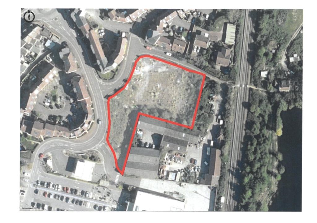
Residential Development Land Approx 0.92 acres Potential for 22no. dwellings
- Bedrooms
- 0
- Bathrooms
- 0
The heatmap indicates the level of crime in the area. The color of the heatmap indicates the crime severity and recency.
Metrics Year-on-Year
- Average area value
- 408,738.00 £Increased by 56.86 %
- Average area rental value
- 1,025.00 £/moIncreased by 11.29 %
- Est rental Yield
- 3.01 %Decreased by 29.01 %
- Crime Rate
- 29.00 %Unchanged by 0.00 %
from 260,569.00 £
from 921.00 £/mo
from 4.24 %
from 29.00 %
Agent Activity
Greenslade Taylor Hunt created the listing.
Nearby Schools
| Name | Type | Ofsted | Distance |
|---|---|---|---|
| Churchfield Church School | Academy Sponsor Led | Good | 0.22 KM |
| Sedgemoor North | Children's Centre | 0.34 KM | |
| The King Alfred School An Academy | Academy Sponsor Led | 0.64 KM | |
| West Huntspill Primary Academy | Academy Sponsor Led | 1.80 KM | |
| Burnham-On-Sea Community Infant School | Community School | Outstanding | 2.04 KM |
Images


Nearby Streets
| Name | Average Price | Average Sqft | Distance |
|---|---|---|---|
| Old Burnham Road | £ 295,939 | 0 | 0.00 KM |
| Jasmine Close | £ 244,950 | 0 | 0.00 KM |
| Field Way | £ 273,625 | 0 | 0.00 KM |
| Coronation Road | £ 289,950 | 0 | 0.00 KM |
| Elder Close | £ 250,000 | 0 | 0.00 KM |
Nearby Transport
| Name | NLC | TLC | Distance |
|---|---|---|---|
| Highbridge And Burnham | 3314 | HIG | 1.00 KM |
Nearby Listings
| Address | Price | Type | Score | Distance |
|---|---|---|---|---|
| Springfield Road, Highbridge, TA9 | £ 500,000 | COMMERCIAL_BUY | Unknown | 0.00 KM |
| Ready to go 29 luxury 1 and 2 bedroom apartments in a prime location | £ 550,000 | COMMERCIAL_BUY | Unknown | 0.64 KM |
Nearby Properties
| Address | Price | Distance |
|---|---|---|
| 22 Burnham Road | £ 180,000 | 0.06 KM |
| 36 Burnham Road | £ 235,000 | 0.06 KM |
| 28 Burnham Road | £ 157,000 | 0.06 KM |
| 26 Burnham Road | £ 150,000 | 0.06 KM |
| 34 Burnham Road | £ 207,500 | 0.06 KM |