
Lanehead Walk, Rugeley, WS15 2XD
By C residential Ltd
£ 230,000
Reviews
4 out of 5 stars
C residential Ltd says ..
** ONLINE VIRTUAL TOUR AVAILABLE ON THIS PROPERTY - why not take a peek before booking a viewing**
Property Oracle says ..
The property is located in Lanehead Walk, Rugeley, Staffordshire, which is in close proximity to several amenities. Etching Hill Cofe Primary Academy is just 0.21km away, and The John Bamford Primary School is 0.34km away. Rugeley Town train station is approximately 2.24km away, offering convenient transport links. The presence of these schools and the train station contributes to a convenient location for families and commuters.
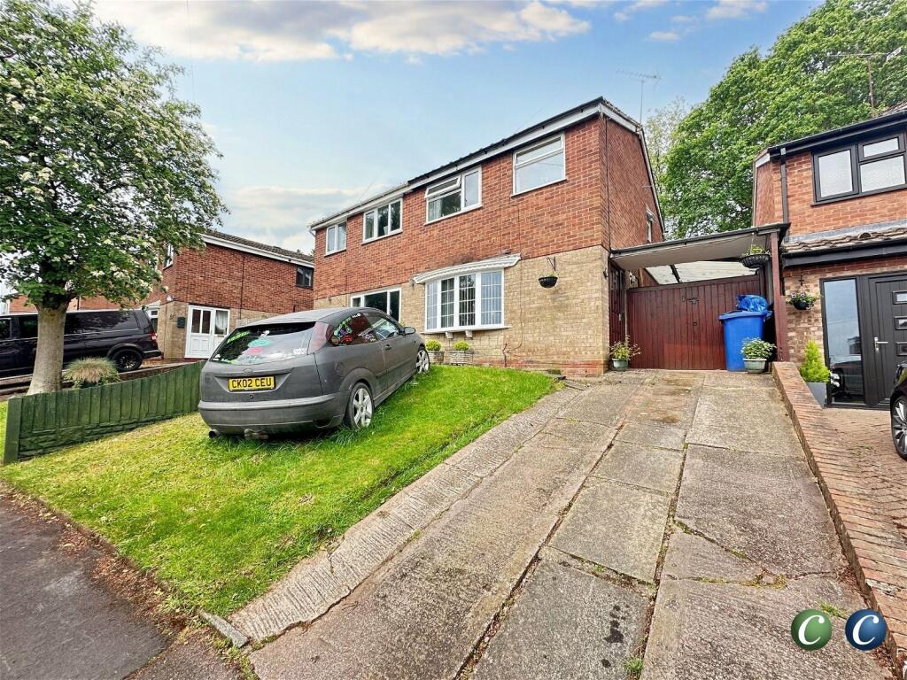
Based on the provided photographs, the property appears to be in good condition. The interior is well-maintained, with updated features in the kitchen and bathroom. There is no visible evidence of significant repairs or renovations needed. The exterior also looks to be in good condition.
The property includes a garden, as shown in the provided photographs. The garden appears to be well-maintained with a patio area, which adds to the overall appeal of the property.
Considering the list price of £230,000, the average price in the area of £571,872, and the average price per square foot of £367, this property seems to be significantly underpriced. While the provided square footage is 1,173.27 sqft, the average sqft for the area is 1,558 sqft. However, the lower price could be attributed to the smaller plot size and the fact that the property is a semi-detached house. The condition of the property and its convenient location should be considered as factors that could justify a higher price. Therefore, the list price appears to represent good value for money, especially considering the condition and location.
Therefore, we give this property 8 / 10. *Disclaimer: This is our option and does constitute a recommendation or financial advice. Do your own research. *
- Price
- 9
- Condition
- 8
- Location
- 8
- Land
- 7
- Bedrooms
- 3
- Bathrooms
- 1
- Sqft (est)
- 1,173.27
The heatmap indicates the level of crime in the area. The color of the heatmap indicates the crime severity and recency.
Metrics Year-on-Year
- Average area value
- 431,054.00 £Increased by 64.12 %
- Est sale value
- 321,475.98 £Increased by 57.47 %
- Average area rental value
- 943.00 £/moIncreased by 7.77 %
- Est letting value
- 0.00 £/mo
- Est rental Yield
- 2.63 %Decreased by 34.25 %
- Crime Rate
- 9.00 %Unchanged by 0.00 %
Agent Activity
C residential Ltd created the listing.
Nearby Schools
| Name | Type | Ofsted | Distance |
|---|---|---|---|
| Etching Hill Cofe Primary Academy | Academy Converter | 0.21 KM | |
| The John Bamford Primary School | Community School | Good | 0.34 KM |
| Forest Hills Primary School | Academy Sponsor Led | 0.73 KM | |
| The Hart School | Academy Sponsor Led | Good | 0.84 KM |
| Chancel Primary School | Community School | Good | 1.93 KM |
Images


Nearby Streets
| Name | Average Price | Average Sqft | Distance |
|---|---|---|---|
| Cambrian Mews | £ 249,950 | 0 | 0.00 KM |
| Moss Green | £ 0 | 0 | 0.00 KM |
| Byron Close | £ 0 | 0 | 0.00 KM |
| Hawthorn Way | £ 0 | 0 | 0.00 KM |
| Mayflower Drive | £ 270,000 | 0 | 0.00 KM |
Nearby Transport
| Name | NLC | TLC | Distance |
|---|---|---|---|
| Rugeley Town | 1135 | RGT | 2.24 KM |
| Rugeley Trent Valley | 1084 | RGL | 2.62 KM |
| Hednesford | 1148 | HNF | 8.23 KM |
Nearby Listings
| Address | Price | Type | Score | Distance |
|---|---|---|---|---|
| Lanehead Walk, Rugeley | £ 220,000 | BUY | 6 / 10 | 0.00 KM |
| Lanehead Walk, Etching Hill, Rugeley | £ 230,000 | BUY | 6 / 10 | 0.01 KM |
| Lanehead Walk, Etching Hill | £ 200,000 | BUY | 6 / 10 | 0.01 KM |
| Lansdowne Way, Rugeley | £ 235,000 | BUY | 7 / 10 | 0.13 KM |
| Gorseburn Way, Rugeley | £ 220,000 | BUY | Unknown | 0.13 KM |
Nearby Properties
| Address | Price | Distance |
|---|---|---|
| 28 Lanehead Walk | £ 220,000 | 0.01 KM |
| 34 Lanehead Walk | £ 160,000 | 0.01 KM |
| 6 Lanehead Walk | £ 173,000 | 0.01 KM |
| 7 Lanehead Walk | £ 63,000 | 0.01 KM |
| 9 Lanehead Walk | £ 220,000 | 0.01 KM |