Northampton Road, Wellingborough, Northamptonshire, NN8 3GZ
By David Wilson Homes
£ 448,995
Reviews
2 out of 5 stars
David Wilson Homes says ..
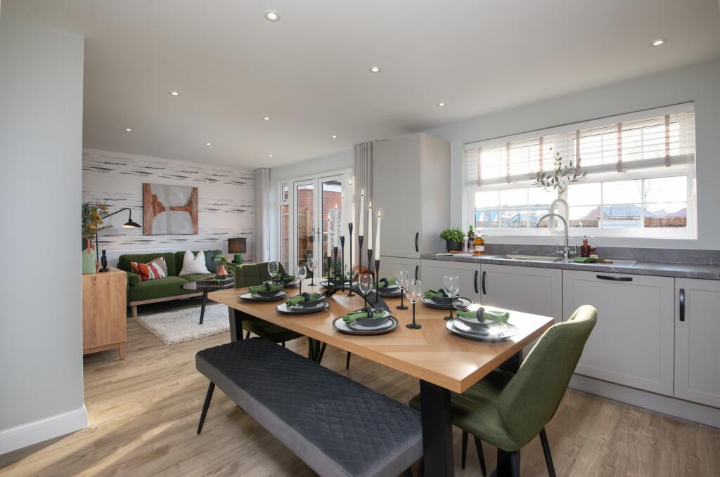
**4 double bedrooms** - open plan kitchen - detached garage - Featuring an open-plan kitchen and dining/family area with French doors opening onto the garden. The bay-fronted lounge offers an ideal place to relax in the evening. Upstairs are three double bedrooms, the main with en suite shower ro...
Property Oracle says ..
The property is a 4-bedroom house listed at £448,995 with a size of 550 sqft and a plot size of 0 sqft. The average house price in the area is £259,400, with an average size of 840 sqft and an average price per sqft of £308. Nearby comparable properties range in price from £372,995 to £467,995, though their sqft is not provided. The property is located near several schools, with Ruskin Infant School and Ruskin Academy being the closest at approximately 0.86 KM and 0.87 KM respectively. Wellingborough train station is 5.05 KM away. The property appears to be in excellent condition based on the provided images. The interior is modern and well-maintained, showing no visible signs of damage or disrepair. The exterior also looks well-maintained. The lack of a garden is a notable drawback. Considering the property’s condition, proximity to schools and transport links, and the relatively higher price compared to the average in the area, the list price seems high. The significantly smaller size (550 sqft) compared to the average (840 sqft) further contributes to this assessment. While comparable properties in the immediate vicinity are similarly priced, their sizes are not provided, making a direct comparison difficult. The lack of a garden also impacts the value.
Therefore, we give this property 5 / 10. *Disclaimer: This is our option and does constitute a recommendation or financial advice. Do your own research. *
- Price
- 4
- Condition
- 10
- Location
- 7
- Land
- 1
- Bedrooms
- 4
- Bathrooms
- 0
- Sqft (est)
- 550.00
The heatmap indicates the level of crime in the area. The color of the heatmap indicates the crime severity and recency.
Metrics Year-on-Year
- Average area value
- 225,298.00 £Decreased by 24.65 %
- Est sale value
- 169,950.00 £Increased by 2.32 %
- Average area rental value
- 1,379.00 £/moIncreased by 20.23 %
- Est letting value
- 550.00 £/moUnchanged by 0.00 %
- Est rental Yield
- 7.34 %Increased by 59.57 %
- Crime Rate
- 12.00 %Unchanged by 0.00 %
Agent Activity
David Wilson Homes created the listing.
Nearby Schools
| Name | Type | Ofsted | Distance |
|---|---|---|---|
| Ruskin Infant School | Academy Converter | 0.86 KM | |
| Ruskin Academy | Academy Sponsor Led | 0.87 KM | |
| Our Lady'S Catholic Primary School | Academy Sponsor Led | 1.06 KM | |
| Wilby Church Of England Primary School | Voluntary Aided School | Good | 1.26 KM |
| Weavers Academy | Academy Sponsor Led | Good | 1.39 KM |
Images


Nearby Streets
| Name | Average Price | Average Sqft | Distance |
|---|---|---|---|
| Park Farm Way | £ 0 | 0 | 0.00 KM |
| Wilby Park Homes | £ 172,139 | 0 | 0.00 KM |
| Wilby Way | £ 450,000 | 0 | 0.00 KM |
| Miranda Way | £ 0 | 0 | 0.00 KM |
| Miranda Way | £ 0 | 0 | 0.00 KM |
Nearby Transport
| Name | NLC | TLC | Distance |
|---|---|---|---|
| Wellingborough | 1940 | WEL | 5.05 KM |
Nearby Listings
| Address | Price | Type | Score | Distance |
|---|---|---|---|---|
| Northampton Road, Wellingborough, Northamptonshire, NN8 3GZ | £ 484,995 | BUY | 5 / 10 | 0.00 KM |
| Northampton Road, Wellingborough, Northamptonshire, NN8 3GZ | £ 441,995 | BUY | 7 / 10 | 0.00 KM |
| Northampton Road, Wellingborough, Northamptonshire, NN8 3GZ | £ 436,995 | BUY | 7 / 10 | 0.00 KM |
| Northampton Road, Wellingborough, Northamptonshire, NN8 3GZ | £ 499,995 | BUY | 6 / 10 | 0.00 KM |
| Northampton Road, Wellingborough, Northamptonshire, NN8 3GZ | £ 429,995 | BUY | 7 / 10 | 0.00 KM |
Nearby Properties
| Address | Price | Distance |
|---|---|---|
| 1 Spinney Lane | £ 325,000 | 0.20 KM |
| 27 Stanwell Way | £ 205,000 | 0.26 KM |
| 23 Stanwell Way | £ 277,000 | 0.26 KM |
| 24 Stanwell Way | £ 190,000 | 0.26 KM |
| 22 Stanwell Way | £ 245,000 | 0.26 KM |