
Lugg Bridge, Worcester Road, Hereford
By Sunderlands
£ 60,000
Reviews
2 out of 5 stars
Sunderlands says ..
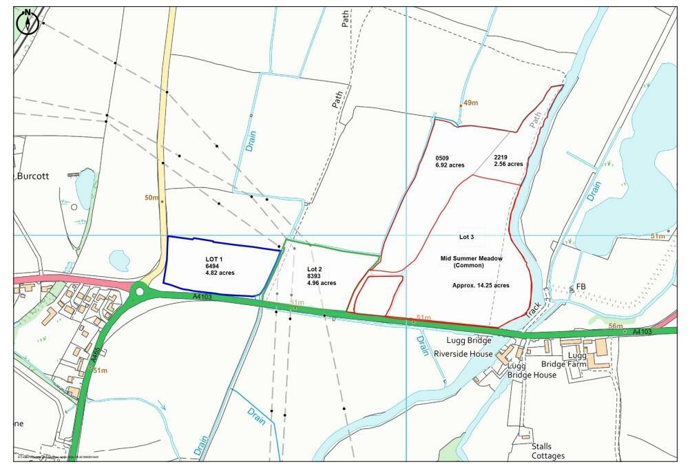
This productive land consists of three adjoining lots, available for purchase individually or as a whole: Lot 2: Approximately 5 acres of similar pasture field to Lot 1, with access onto Worcester Road. All land is within the flood plain of the River Lugg and requires a small an...
Property Oracle says ..
This listing presents a plot of agricultural land situated near Lugg Bridge in Herefordshire. The key feature is the substantial size of the land parcel, offering approximately 6.62 acres (Lot 1). The property is well-situated near the A438, offering convenient road access, with a number of schools within a reasonable distance. However, the location is relatively isolated, lacking the immediate convenience of shops and other local amenities. The land is presented as undeveloped grassland. There are no buildings or structures shown in the provided images. The price, at £60,000, should be considered within the context of potential development costs and the acknowledged flood risk mentioned in relation to the nearby properties. The absence of detailed information regarding the soil type, permitted uses, and any potential planning restrictions prevents a full and comprehensive evaluation of the land’s potential and value. In addition, the lack of details regarding the building potential of the land, and the lack of buildings or structures, impact the analysis. It’s important to conduct further due diligence, including a land survey and planning application investigations, prior to any commitment to purchase.
Therefore, we give this property 5 / 10. *Disclaimer: This is our option and does constitute a recommendation or financial advice. Do your own research. *
- Price
- 7
- Condition
- 5
- Location
- 4
- Land
- 7
- Bedrooms
- 0
- Bathrooms
- 0


The heatmap indicates the level of crime in the area. The color of the heatmap indicates the crime severity and recency.
Metrics Year-on-Year
- Average area value
- 298,752.00 £Decreased by 12.72 %
- Average area rental value
- 952.00 £/moDecreased by 29.74 %
- Est rental Yield
- 3.82 %Decreased by 19.58 %
- Crime Rate
- 0.00 %
Agent Activity
Sunderlands created the listing.
Nearby Schools
| Name | Type | Ofsted | Distance |
|---|---|---|---|
| St Mary'S Rc High School | Voluntary Aided School | Outstanding | 1.05 KM |
| The Bishop Of Hereford'S Bluecoat School | Voluntary Aided School | Good | 1.78 KM |
| St Paul'S Cofe Primary School | Academy Converter | Outstanding | 1.87 KM |
| Hampton Dene Primary School | Community School | Good | 2.23 KM |
| Lugwardine Primary Academy | Academy Converter | Good | 2.55 KM |
Images
Nearby Streets
| Name | Average Price | Average Sqft | Distance |
|---|---|---|---|
| A438 | £ 0 | 0 | 0.00 KM |
| Hemhill | £ 775,000 | 0 | 0.00 KM |
| Hampton Dene Road | £ 0 | 0 | 0.00 KM |
| Braemar Gardens | £ 600,000 | 0 | 0.00 KM |
| Salisbury Avenue | £ 650,000 | 0 | 0.00 KM |
Nearby Transport
| Name | NLC | TLC | Distance |
|---|---|---|---|
| Hereford | 3607 | HFD | 4.45 KM |
Nearby Listings
| Address | Price | Type | Score | Distance |
|---|---|---|---|---|
| Lugwardine, Hereford, HR1 | £ 325,000 | BUY | 7 / 10 | 0.69 KM |
| Traherne Close, Lugwardine, HEREFORD | £ 420,000 | BUY | 6 / 10 | 0.99 KM |
| Lugwardine, Hereford, HR1 | £ 375,000 | BUY | 5 / 10 | 1.07 KM |
| The Steppes Holiday Cottages, Lugwardine, Hereford, Herefordshire, HR1 4AL | £ 775,000 | BUY | Unknown | 1.18 KM |
| Mantella Drive, Tupsley, Hereford | £ 475,000 | BUY | Unknown | 1.38 KM |
Nearby Properties
| Address | Price | Distance |
|---|---|---|
| 2 Lugwardine Court Orchard | £ 215,000 | 0.76 KM |
| 4 Lugwardine Court Orchard | £ 173,000 | 0.76 KM |
| 7 Lugwardine Court Orchard | £ 85,950 | 0.76 KM |
| 9 Lugwardine Court Orchard | £ 175,000 | 0.76 KM |
| 10 Lugwardine Court Orchard | £ 210,000 | 0.76 KM |