BU
Kingsway, Manchester M19 2ND
By Buraq Estates
£ 1,195
Buraq Estates says ..
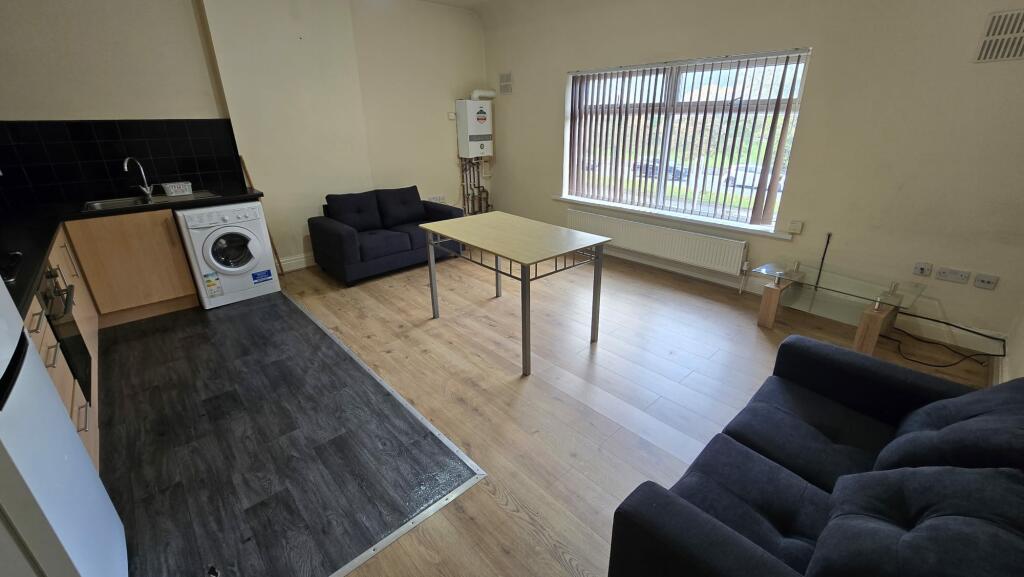
2 Bedroom freshly painted flat with new furniture, new beds and mattresses and new carpet.
- Bedrooms
- 2
- Bathrooms
- 1
The heatmap indicates the level of crime in the area. The color of the heatmap indicates the crime severity and recency.
Metrics Year-on-Year
- Average area value
- 320,833.00 £Increased by 5.35 %
- Average area rental value
- 1,380.00 £/moDecreased by 15.49 %
- Est rental Yield
- 5.16 %Decreased by 19.75 %
- Crime Rate
- 0.00 %
from 304,545.00 £
from 1,633.00 £/mo
from 6.43 %
from 0.00 %
Agent Activity
Buraq Estates created the listing.
Nearby Schools
| Name | Type | Ofsted | Distance |
|---|---|---|---|
| Mauldeth Road Primary School | Community School | Good | 0.42 KM |
| Burnage Sure Start Children'S Centre | Children's Centre | 0.58 KM | |
| Cringle Brook Primary School | Free Schools | Outstanding | 0.73 KM |
| Acacias Community Primary School | Community School | Good | 0.79 KM |
| Green End Primary School | Academy Converter | Outstanding | 0.84 KM |
Images


Nearby Streets
| Name | Average Price | Average Sqft | Distance |
|---|---|---|---|
| Kingswood Road | £ 0 | 0 | 0.00 KM |
| Harwood Road | £ 242,500 | 0 | 0.00 KM |
| Kenwood Avenue | £ 370,000 | 0 | 0.00 KM |
| Lindleywood Road | £ 0 | 0 | 0.00 KM |
| Fallowfield Loop | £ 0 | 0 | 0.00 KM |
Nearby Transport
| Name | NLC | TLC | Distance |
|---|---|---|---|
| Mauldeth Road | 2867 | MAU | 0.43 KM |
| Levenshulme | 2862 | LVM | 1.78 KM |
| Burnage | 2945 | BNA | 1.92 KM |
| Heaton Chapel | 2861 | HTC | 3.23 KM |
| East Didsbury | 2949 | EDY | 3.41 KM |
Nearby Listings
| Address | Price | Type | Score | Distance |
|---|---|---|---|---|
| Kingsway, Manchester | £ 1,195 | RENT | Unknown | 0.07 KM |
| Talbot Road, Manchester, M14 | £ 130 | RENT | Unknown | 0.20 KM |
| Wald Avenue, Manchester, M14 | £ 4,974 | RENT | Unknown | 0.23 KM |
| Kingswood Road, Manchester, M14 | £ 3,336 | RENT | Unknown | 0.25 KM |
| Kingswood Road, Manchester, M14 | £ 2,860 | RENT | Unknown | 0.25 KM |
Nearby Properties
| Address | Price | Distance |
|---|---|---|
| 173a Kingsway | £ 112,000 | 0.03 KM |
| 179 Kingsway | £ 290,000 | 0.03 KM |
| 175 Kingsway | £ 141,000 | 0.03 KM |
| 195 Kingsway | £ 55,000 | 0.03 KM |
| 14 Burnside Drive | £ 295,000 | 0.08 KM |