
Burnwood Close, Chopwell, Newcastle upon Tyne, Tyne and Wear, NE17
By YOUR MOVE Chris Stonock
£ 300,000
Reviews
3 out of 5 stars
YOUR MOVE Chris Stonock says ..
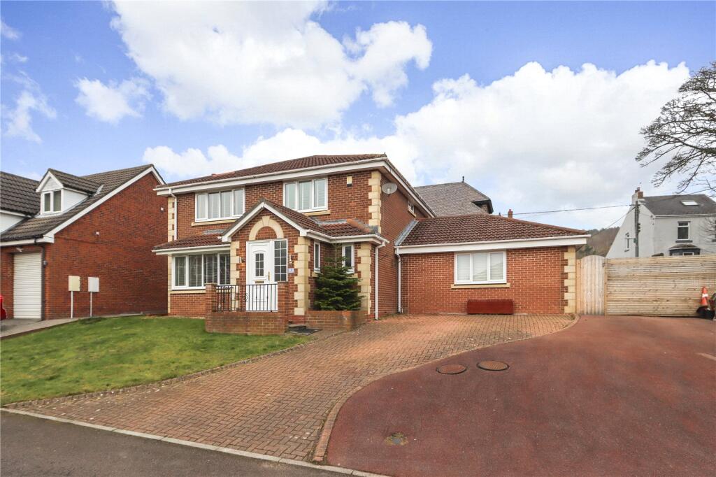
A spacious, extended four-bedroom detached house with a generous driveway and a converted garage to provide additional living space, situated at the edge of this small cul-de-sac development in Chopwell village.
Property Oracle says ..
The property is a 4-bedroom, 2-bathroom house with a total area of 1,673 sqft situated on a 724 sqft plot. The list price is £300,000. The average price for properties in the Chopwell And Rowlands Gill area is £176,020, with an average price per sqft of £227. This property is significantly larger than the average at 1673 sqft compared to the average of 775 sqft. The property appears to be in good condition based on the provided photographs. The interior is modern and well-maintained, suggesting recent renovations or upgrades. The exterior also presents well. The presence of a garden, albeit relatively small, is a positive feature. The location in Chopwell, Tyne and Wear benefits from the proximity of Chopwell Primary School (rated ‘Good’ by Ofsted), which is a significant advantage for families. The relatively close proximity to train stations at Wylam and Prudhoe provides access to public transportation. Considering the property’s size (1673 sqft), condition, and location, the list price of £300,000 appears relatively high compared to the average property price in the area (£176,020). However, the significantly larger size of the property compared to the average needs to be considered. More comparable properties in the area would be needed to accurately assess the price.
Therefore, we give this property 6 / 10. *Disclaimer: This is our option and does constitute a recommendation or financial advice. Do your own research. *
- Price
- 6
- Condition
- 8
- Location
- 7
- Land
- 6
- Bedrooms
- 4
- Bathrooms
- 2
- Sqft (est)
- 1,673.00
- Lot (est)
- 724.00
The heatmap indicates the level of crime in the area. The color of the heatmap indicates the crime severity and recency.
Metrics Year-on-Year
- Average area value
- 176,429.00 £Decreased by 14.37 %
- Est sale value
- 245,931.00 £Decreased by 30.00 %
- Average area rental value
- 675.00 £/moIncreased by 8.52 %
- Est letting value
- 0.00 £/mo
- Est rental Yield
- 4.59 %Increased by 26.80 %
- Crime Rate
- 29.00 %Unchanged by 0.00 %
Agent Activity
YOUR MOVE Chris Stonock created the listing.
Nearby Schools
| Name | Type | Ofsted | Distance |
|---|---|---|---|
| Chopwell Primary School | Community School | Good | 0.33 KM |
| Chopwell And Highfield Children'S Centre | Children's Centre Linked Site | 0.33 KM | |
| Ebchester Cofe Primary School | Voluntary Controlled School | Good | 3.50 KM |
| Bishop Ian Ramsey Cofe Primary School | Academy Sponsor Led | 3.82 KM | |
| High Spen Primary School | Community School | Good | 4.18 KM |
Images


Nearby Streets
| Name | Average Price | Average Sqft | Distance |
|---|---|---|---|
| Elizabeth Street | £ 87,500 | 0 | 0.00 KM |
| Ravensworth Terrace | £ 60,000 | 0 | 0.00 KM |
| Prince Street | £ 0 | 0 | 0.00 KM |
| South View | £ 0 | 0 | 0.00 KM |
| Hall Road | £ 0 | 0 | 0.00 KM |
Nearby Transport
| Name | NLC | TLC | Distance |
|---|---|---|---|
| Wylam | 7514 | WYM | 6.31 KM |
| Prudhoe | 7509 | PRU | 7.19 KM |
Nearby Listings
| Address | Price | Type | Score | Distance |
|---|---|---|---|---|
| Burnwood Close, Chopwell, ., ., NE17 | £ 299,950 | BUY | 7 / 10 | 0.00 KM |
| Burnwood Close, Chopwell, Newcastle upon Tyne, Tyne and Wear, NE17 | £ 300,000 | BUY | 6 / 10 | 0.00 KM |
| Havelock Terrace, Chopwell, Newcastle upon Tyne, NE17 | £ 75,000 | BUY | 6 / 10 | 0.06 KM |
| Havelock Terrace, Chopwell, Newcastle upon Tyne, Tyne and Wear, NE17 | £ 120,000 | BUY | 7 / 10 | 0.08 KM |
| William Street, Chopwell, Newcastle upon Tyne, NE17 | £ 60,000 | BUY | 6 / 10 | 0.12 KM |
Nearby Properties
| Address | Price | Distance |
|---|---|---|
| West School House | £ 111,000 | 0.04 KM |
| Derwent House | £ 116,000 | 0.04 KM |
| 1 Whittonstall Road | £ 190,000 | 0.04 KM |
| 2 Burnwood Close | £ 160,000 | 0.07 KM |
| 1 Burnwood Close | £ 220,000 | 0.07 KM |