Farrier Street, Worcester, Worcestershire, WR1 3BH
By Platinum Property Support Ltd
£ 3,500,000
Reviews
2 out of 5 stars
Platinum Property Support Ltd says ..
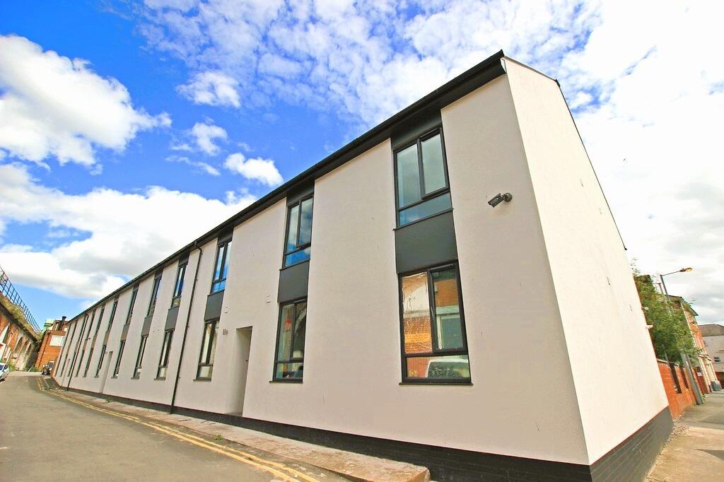
This spacious 48-bedroom house in Worcester features modern living spaces, fitted kitchen, student let (HMO), and ample street parking. Situated just a four-minute walk from the University of Worcester City Campus.
Property Oracle says ..
The property is located on Farrier Street in Worcester, a city in Worcestershire, England. The location is close to Worcester Foregate Street train station (0.23km), providing convenient access to transportation links. Several schools are also within a reasonable distance, including Royal Grammar School Worcester (0.52km), St George’s Catholic Primary School (0.83km), and St George’s Cofe Primary School (0.96km). The property itself appears to be a modern, multi-unit building, possibly student accommodation or apartments. Based on the images, the property seems to be in good condition, with a clean and well-maintained exterior and interior. The images showcase modern fixtures and finishes in the kitchen and bathrooms. There is no visible evidence of significant repairs or renovations needed. The plot size is listed as 0.00 sqft, indicating that there is no garden or significant outdoor space associated with the property. The list price is £3,500,000. Considering the average price in the area is £280,686 and the average price per sqft is £290, the list price is significantly higher. However, this property is a multi-unit building with 48 bedrooms and 48 bathrooms, suggesting a high rental income potential. The high price may be justified by the potential return on investment, rather than solely based on the property itself.
Therefore, we give this property 5 / 10. *Disclaimer: This is our option and does constitute a recommendation or financial advice. Do your own research. *
- Price
- 4
- Condition
- 9
- Location
- 8
- Land
- 1
- Bedrooms
- 48
- Bathrooms
- 48
- Sqft (est)
- 2,100.00
The heatmap indicates the level of crime in the area. The color of the heatmap indicates the crime severity and recency.
Metrics Year-on-Year
- Average area value
- 306,076.00 £Increased by 13.87 %
- Est sale value
- 577,500.00 £Increased by 0.36 %
- Average area rental value
- 1,012.00 £/moIncreased by 13.33 %
- Est letting value
- 0.00 £/mo
- Est rental Yield
- 3.97 %Decreased by 0.50 %
- Crime Rate
- 32.00 %Unchanged by 0.00 %
Agent Activity
Platinum Property Support Ltd created the listing.
Nearby Schools
| Name | Type | Ofsted | Distance |
|---|---|---|---|
| Royal Grammar School Worcester | Other Independent School | 0.52 KM | |
| St George'S Catholic Primary School | Voluntary Aided School | Good | 0.83 KM |
| St George'S Cofe Primary School | Voluntary Aided School | Requires improvement | 0.96 KM |
| Riversides School | Academy Special Sponsor Led | Good | 1.00 KM |
| The King'S School | Other Independent School | 1.02 KM |
Images


Nearby Streets
| Name | Average Price | Average Sqft | Distance |
|---|---|---|---|
| Mc Naught Place | £ 0 | 0 | 0.00 KM |
| Netherton Court | £ 0 | 0 | 0.00 KM |
| Hop Market | £ 0 | 0 | 0.00 KM |
| Crowngate Chapel Walk | £ 0 | 0 | 0.00 KM |
| St Swithin's Street | £ 0 | 0 | 0.00 KM |
Nearby Transport
| Name | NLC | TLC | Distance |
|---|---|---|---|
| Worcester Foregate Street | 4893 | WOF | 0.23 KM |
| Worcester Shrub Hill | 4891 | WOS | 1.55 KM |
| Worcestershire Parkway | 6580 | WOP | 8.31 KM |
Nearby Listings
| Address | Price | Type | Score | Distance |
|---|---|---|---|---|
| Farrier Street, Worcester, Worcestershire, WR1 3BH | £ 3,500,000 | BUY | 5 / 10 | 0.00 KM |
| Apartment 8, Vinegar House, Foregate Street, Worcester. WR1 1DJ | £ 145,000 | BUY | 7 / 10 | 0.03 KM |
| The Loft, Apartment 12, Vinegar House, Foregate Street, Worcester. WR1 1DJ | £ 130,000 | BUY | 7 / 10 | 0.03 KM |
| Apartment 6, Vinegar House, Foregate Street, Worcester. WR1 1DJ | £ 345,000 | BUY | 7 / 10 | 0.03 KM |
| 38 Foregate Street, Worcester | £ 115,000 | BUY | 6 / 10 | 0.05 KM |
Nearby Properties
| Address | Price | Distance |
|---|---|---|
| 43b The Tything | £ 118,000 | 0.13 KM |
| 6a The Tything | £ 85,000 | 0.17 KM |
| 28 Surman Street | £ 155,000 | 0.21 KM |
| 46 Surman Street | £ 280,000 | 0.21 KM |
| 52 Surman Street | £ 275,000 | 0.21 KM |