Ashdale Drive, Manchester, Greater Manchester, M20
By Bridgfords
£ 300,000
Reviews
3 out of 5 stars
Bridgfords says ..
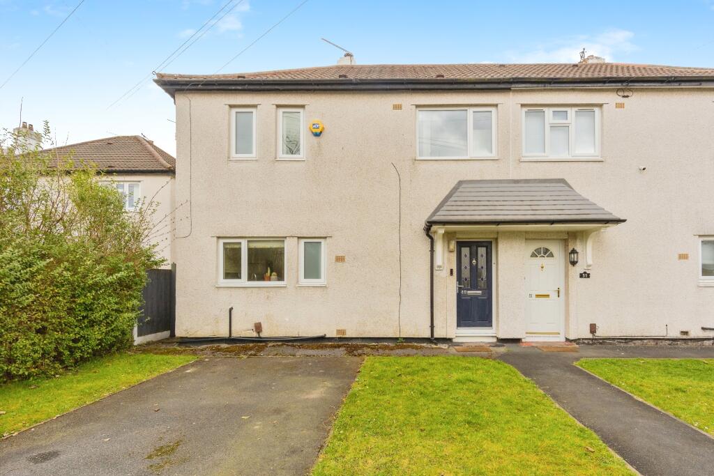
Nestled in a sought-after location between Fog Lane and Lady Barn Parks, this charming semi-detached home offers a perfect blend of modern living and convenience. Ideally positioned for commuters, the property is within easy reach of Burnage and Mauldeth Road train stations, providing direct acce...
Property Oracle says ..
This three-bedroom semi-detached house in Burnage, Manchester is located close to several highly-rated schools and has good transport links. The property itself appears to be in good condition, with a recently modernised kitchen and bathroom. There is a garden to the rear, although the size is not specified. The list price of £300,000 is slightly below the average price for the area (£320,421), but this needs to be considered in relation to the size of the property (965.52 sqft) which is smaller than the average (1001 sqft). The average price per sqft in the area is £320, suggesting that the list price may represent good value for money. However, more information on the plot size would enable a more definitive conclusion. Nearby properties with similar characteristics are priced similarly, supporting the reasonableness of the asking price.
Therefore, we give this property 7 / 10. *Disclaimer: This is our option and does constitute a recommendation or financial advice. Do your own research. *
- Price
- 7
- Condition
- 8
- Location
- 7
- Land
- 6
- Bedrooms
- 3
- Bathrooms
- 1
- Sqft (est)
- 965.52
The heatmap indicates the level of crime in the area. The color of the heatmap indicates the crime severity and recency.
Metrics Year-on-Year
- Average area value
- 320,833.00 £Increased by 5.35 %
- Est sale value
- 495,311.76 £Increased by 67.10 %
- Average area rental value
- 1,380.00 £/moDecreased by 15.49 %
- Est letting value
- 1,931.04 £/moIncreased by 100.00 %
- Est rental Yield
- 5.16 %Decreased by 19.75 %
- Crime Rate
- 0.00 %
Agent Activity
Bridgfords created the listing.
Nearby Schools
| Name | Type | Ofsted | Distance |
|---|---|---|---|
| Ladybarn Primary School | Academy Converter | 0.49 KM | |
| St Cuthbert'S Rc Primary School | Voluntary Aided School | Good | 0.99 KM |
| Burnage Academy For Boys | Academy Converter | Outstanding | 1.00 KM |
| Mauldeth Road Primary School | Community School | Good | 1.02 KM |
| Burnage Sure Start Children'S Centre | Children's Centre | 1.13 KM |
Images


Nearby Streets
| Name | Average Price | Average Sqft | Distance |
|---|---|---|---|
| Harwood Road | £ 242,500 | 0 | 0.00 KM |
| Lyth Street | £ 0 | 0 | 0.00 KM |
| Albury Drive | £ 0 | 0 | 0.00 KM |
| Kenwood Avenue | £ 370,000 | 0 | 0.00 KM |
| Swinly Crescent | £ 0 | 0 | 0.00 KM |
Nearby Transport
| Name | NLC | TLC | Distance |
|---|---|---|---|
| Burnage | 2945 | BNA | 0.58 KM |
| Mauldeth Road | 2867 | MAU | 0.94 KM |
| East Didsbury | 2949 | EDY | 2.07 KM |
| Levenshulme | 2862 | LVM | 3.11 KM |
| Heaton Chapel | 2861 | HTC | 3.90 KM |
Nearby Listings
| Address | Price | Type | Score | Distance |
|---|---|---|---|---|
| Ashdale Drive, Manchester, Greater Manchester, M20 | £ 300,000 | BUY | 7 / 10 | 0.00 KM |
| Newville Drive, Withington | £ 325,000 | BUY | 7 / 10 | 0.10 KM |
| Southlea Road, Manchester, Greater Manchester, M20 | £ 280,000 | BUY | 7 / 10 | 0.11 KM |
| Newville Drive, Withington, Burnage, Manchester, Greater Manchester, M20 | £ 215,000 | BUY | Unknown | 0.14 KM |
| Southlea Road, Withington | £ 310,000 | BUY | 7 / 10 | 0.14 KM |
Nearby Properties
| Address | Price | Distance |
|---|---|---|
| 45 Southlea Road | £ 190,000 | 0.11 KM |
| 61 Southlea Road | £ 303,000 | 0.11 KM |
| 65 Southlea Road | £ 219,950 | 0.11 KM |
| 43 Southlea Road | £ 135,000 | 0.11 KM |
| 21 Southlea Road | £ 265,000 | 0.11 KM |