UN
64 Lime Close
£ 90,000
Description
We don't have a Description for this property.
- Bedrooms
- 2
- Bathrooms
- 0

Leaflet © OpenStreetMap contributors
The heatmap indicates the level of crime in the area. The color of the heatmap indicates the crime severity and recency.
Metrics Year-on-Year
- Average area value
- 341,429.00 £Increased by 9.95 %
- Average area rental value
- 875.00 £/moDecreased by 18.53 %
- Est rental Yield
- 3.08 %Decreased by 25.78 %
- Crime Rate
- 5.00 %Unchanged by 0.00 %
from 310,533.00 £
from 1,074.00 £/mo
from 4.15 %
from 5.00 %
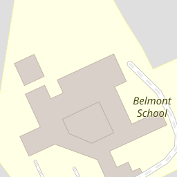
Nearby Schools
| Name | Type | Ofsted | Distance |
|---|---|---|---|
| Belmont School | Community School | Outstanding | 0.11 KM |
| St Joseph'S Catholic Primary School | Academy Converter | 0.66 KM | |
| Gange | Children's Centre Linked Site | 0.86 KM | |
| Weald Rise Primary School | Community School | Good | 0.92 KM |
| The Sacred Heart Language College | Academy Converter | 1.04 KM |
Images
Nearby Streets
| Name | Average Price | Average Sqft | Distance |
|---|---|---|---|
| Kenton Lane | £ 0 | 0 | 0.00 KM |
| The Broadway | £ 550,000 | 0 | 0.00 KM |
| Stirling Road | £ 525,000 | 0 | 0.00 KM |
| Burnham Close | £ 0 | 0 | 0.00 KM |
| Palmerston Road | £ 0 | 0 | 0.00 KM |
Nearby Transport
| Name | NLC | TLC | Distance |
|---|---|---|---|
| Harrow And Wealdstone | 1397 | HRW | 1.25 KM |
| Kenton | 1399 | KNT | 2.34 KM |
| Harrow-On-The-Hill | 598 | HOH | 2.63 KM |
| Headstone Lane | 1434 | HDL | 3.37 KM |
| South Kenton | 1453 | SOK | 3.93 KM |
Nearby Listings
| Address | Price | Type | Score | Distance |
|---|---|---|---|---|
| Lime Close, Harrow | £ 225,000 | BUY | 7 / 10 | 0.00 KM |
| Lime Close, Harrow | £ 235,000 | BUY | Unknown | 0.03 KM |
| Lime Close, Harrow, Greater London, HA3 | £ 269,950 | BUY | Unknown | 0.05 KM |
| Lime Close, Harrow | £ 275,000 | BUY | Unknown | 0.06 KM |
| Fisher Road, Harrow, Middlesex | £ 500,000 | BUY | 6 / 10 | 0.07 KM |
Nearby Properties
| Address | Price | Distance |
|---|---|---|
| 83 Lime Close | £ 129,000 | 0.00 KM |
| 77 Lime Close | £ 25,000 | 0.00 KM |
| 64 Lime Close | £ 90,000 | 0.00 KM |
| 72 Lime Close | £ 139,000 | 0.00 KM |
| 79 Lime Close | £ 169,950 | 0.00 KM |