UN
3 Airedale
£ 134,950
Description
We don't have a Description for this property.
- Bedrooms
- 2
- Bathrooms
- 0
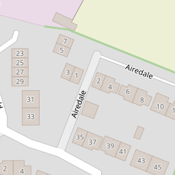

Leaflet © OpenStreetMap contributors
The heatmap indicates the level of crime in the area. The color of the heatmap indicates the crime severity and recency.
Metrics Year-on-Year
- Average area value
- 407,139.00 £Decreased by 4.00 %
- Average area rental value
- 1,723.00 £/moIncreased by 16.11 %
- Est rental Yield
- 5.08 %Increased by 20.95 %
- Crime Rate
- 16.00 %Unchanged by 0.00 %
from 424,119.00 £
from 1,484.00 £/mo
from 4.20 %
from 16.00 %
Nearby Schools
| Name | Type | Ofsted | Distance |
|---|---|---|---|
| Ellel St John The Evangelist Church Of England Primary School | Voluntary Aided School | Good | 0.31 KM |
| Galgate Children'S Centre | Children's Centre Linked Site | 0.33 KM | |
| University Of Lancaster | Higher Education Institutions | 1.79 KM | |
| Moorside Primary School | Community School | Good | 4.23 KM |
| Stepping Stones School | Pupil Referral Unit | Outstanding | 4.23 KM |
Images
Nearby Streets
| Name | Average Price | Average Sqft | Distance |
|---|---|---|---|
| Ashley Gardens | £ 299,950 | 0 | 0.00 KM |
| Scotforth Road | £ 0 | 0 | 0.00 KM |
Nearby Transport
| Name | NLC | TLC | Distance |
|---|---|---|---|
| Lancaster | 2685 | LAN | 6.50 KM |
Nearby Listings
| Address | Price | Type | Score | Distance |
|---|---|---|---|---|
| Airedale, Galgate, Lancaster | £ 299,950 | BUY | Unknown | 0.01 KM |
| Airedale, Galgate, LA2 | £ 280,000 | BUY | Unknown | 0.06 KM |
| Crofters Fold, Galgate | Check out the large, fabulous extension! | £ 310,000 | BUY | Unknown | 0.09 KM |
| Crofters Fold, Galgate | Easy accesss to Lancaster University, major transport links, including the M6 motorway, | £ 190,000 | BUY | Unknown | 0.10 KM |
| Wharfedale, Galgate, Lancaster | £ 289,950 | BUY | 7 / 10 | 0.12 KM |
Nearby Properties
| Address | Price | Distance |
|---|---|---|
| 3 Airedale | £ 134,950 | 0.00 KM |
| 5 Airedale | £ 161,000 | 0.00 KM |
| 1 Airedale | £ 133,000 | 0.00 KM |
| 2 Airedale | £ 162,000 | 0.00 KM |
| 10 Airedale | £ 210,000 | 0.00 KM |