UN
97 Kingsgate Avenue
£ 500,000
Description
We don't have a Description for this property.
- Bedrooms
- 4
- Bathrooms
- 0
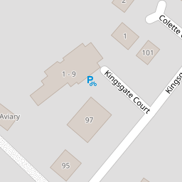

Leaflet © OpenStreetMap contributors
The heatmap indicates the level of crime in the area. The color of the heatmap indicates the crime severity and recency.
Metrics Year-on-Year
- Average area value
- 530,300.00 £Decreased by 23.26 %
- Average area rental value
- 1,232.00 £/moIncreased by 37.81 %
- Est rental Yield
- 2.79 %Increased by 80.00 %
- Crime Rate
- 28.00 %Unchanged by 0.00 %
from 691,060.00 £
from 894.00 £/mo
from 1.55 %
from 28.00 %
Nearby Schools
| Name | Type | Ofsted | Distance |
|---|---|---|---|
| St Peter-In-Thanet Cofe Junior School | Voluntary Aided School | Good | 1.95 KM |
| Callis Grange Nursery And Infant School | Community School | Outstanding | 1.98 KM |
| Callis Grange Children'S Centre | Children's Centre | 2.07 KM | |
| Stone Bay School | Foundation Special School | Good | 2.37 KM |
| St Joseph'S Catholic Primary School, Broadstairs | Academy Converter | Good | 2.57 KM |
Images
Nearby Streets
| Name | Average Price | Average Sqft | Distance |
|---|---|---|---|
| Kingsgate Court | £ 325,000 | 0 | 0.00 KM |
| Second Avenue | £ 537,688 | 0 | 0.00 KM |
| Marine Drive | £ 1,265,000 | 0 | 0.00 KM |
| Oakridge | £ 877,500 | 0 | 0.00 KM |
| Woodland Way | £ 566,667 | 0 | 0.00 KM |
Nearby Transport
| Name | NLC | TLC | Distance |
|---|---|---|---|
| Broadstairs | 5006 | BSR | 2.92 KM |
| Dumpton Park | 5034 | DMP | 4.71 KM |
| Ramsgate | 5023 | RAM | 6.09 KM |
| Margate | 5018 | MAR | 7.13 KM |
Nearby Listings
| Address | Price | Type | Score | Distance |
|---|---|---|---|---|
| Kingsgate Avenue, Broadstairs, Kent | £ 512,000 | BUY | 9 / 10 | 0.01 KM |
| Kingsgate Avenue, Broadstairs, Kent | £ 775,000 | BUY | 8 / 10 | 0.01 KM |
| Kingsgate Avenue, Broadstairs, CT10 | £ 640,000 | BUY | 8 / 10 | 0.04 KM |
| Colette Close, Broadstairs | £ 700,000 | BUY | 6 / 10 | 0.08 KM |
| Kingsgate Avenue, Broadstairs, CT10 | £ 285,000 | BUY | 7 / 10 | 0.09 KM |
Nearby Properties
| Address | Price | Distance |
|---|---|---|
| 97 Kingsgate Avenue | £ 500,000 | 0.00 KM |
| 102a Kingsgate Avenue | £ 148,000 | 0.05 KM |
| 101 Kingsgate Avenue | £ 290,000 | 0.05 KM |
| 106 Kingsgate Avenue | £ 645,000 | 0.05 KM |
| 98 Kingsgate Avenue | £ 125,000 | 0.05 KM |