UN
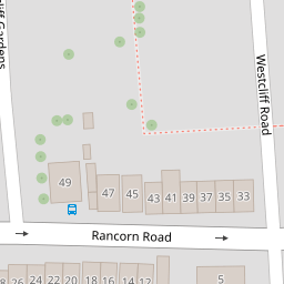
9 Rancorn Road
£ 550,000
Description
We don't have a Description for this property.
- Bedrooms
- 4
- Bathrooms
- 0
- Sqft
- 1,560.00


Leaflet © OpenStreetMap contributors
The heatmap indicates the level of crime in the area. The color of the heatmap indicates the crime severity and recency.
Metrics Year-on-Year
- Average area value
- 388,911.00 £Increased by 22.75 %
- Est sale value
- 580,320.00 £Increased by 67.57 %
- Average area rental value
- 1,179.00 £/moIncreased by 9.57 %
- Est letting value
- 1,560.00 £/mo
- Est rental Yield
- 3.64 %Decreased by 10.78 %
- Crime Rate
- 14.00 %Unchanged by 0.00 %
from 316,822.00 £
from 346,320.00 £
from 1,076.00 £/mo
from 0.00 £/mo
from 4.08 %
from 14.00 %
Nearby Schools
| Name | Type | Ofsted | Distance |
|---|---|---|---|
| Cherry Tree | Other Independent Special School | Good | 0.22 KM |
| Garlinge Children'S Centre | Children's Centre | 0.69 KM | |
| Hartsdown Academy | Academy Converter | Requires improvement | 0.72 KM |
| Garlinge Primary School And Nursery | Foundation School | Good | 0.77 KM |
| St Gregory'S Catholic Primary School, Margate | Academy Converter | Good | 1.87 KM |
Images
Nearby Streets
| Name | Average Price | Average Sqft | Distance |
|---|---|---|---|
| Pembroke Avenue | £ 450,000 | 0 | 0.00 KM |
| Meadow Road | £ 775,000 | 0 | 0.00 KM |
| All Saints Avenue | £ 0 | 0 | 0.00 KM |
| Brook Close | £ 265,000 | 0 | 0.00 KM |
| Roman Way | £ 307,500 | 0 | 0.00 KM |
Nearby Transport
| Name | NLC | TLC | Distance |
|---|---|---|---|
| Margate | 5018 | MAR | 0.85 KM |
| Westgate-On-Sea | 5195 | WGA | 2.90 KM |
| Ramsgate | 5023 | RAM | 6.69 KM |
| Birchington-On-Sea | 5163 | BCH | 7.01 KM |
| Dumpton Park | 5034 | DMP | 8.02 KM |
Nearby Listings
| Address | Price | Type | Score | Distance |
|---|---|---|---|---|
| Rancorn Road, Margate, CT9 | £ 145,000 | BUY | 5 / 10 | 0.02 KM |
| Westbrook Gardens, Margate, Kent, CT9 | £ 650,000 | BUY | 5 / 10 | 0.04 KM |
| Westbrook Gardens, Margate | £ 150,000 | BUY | Unknown | 0.04 KM |
| Rancorn Road, Margate | £ 135,000 | BUY | 5 / 10 | 0.07 KM |
| Rancorn Road, Margate | £ 175,000 | BUY | Unknown | 0.07 KM |
Nearby Properties
| Address | Price | Distance |
|---|---|---|
| 9 Rancorn Road | £ 550,000 | 0.00 KM |
| 19 Rancorn Road | £ 470,000 | 0.00 KM |
| 17 Rancorn Road | £ 525,000 | 0.00 KM |
| 23 Rancorn Road | £ 118,000 | 0.02 KM |
| 8 Rancorn Road | £ 168,000 | 0.02 KM |