UN
6 Miles Close
£ 391,500
Description
We don't have a Description for this property.
- Bedrooms
- 4
- Bathrooms
- 0
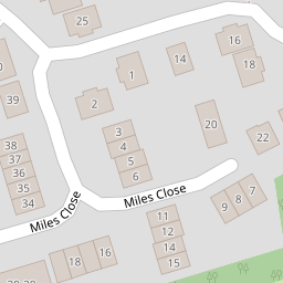

Leaflet © OpenStreetMap contributors
The heatmap indicates the level of crime in the area. The color of the heatmap indicates the crime severity and recency.
Metrics Year-on-Year
- Average area value
- 740,833.00 £Increased by 11.45 %
- Average area rental value
- 1,310.00 £/moDecreased by 18.12 %
- Est rental Yield
- 2.12 %Decreased by 26.64 %
- Crime Rate
- 4.00 %Unchanged by 0.00 %
from 664,697.00 £
from 1,600.00 £/mo
from 2.89 %
from 4.00 %
Nearby Schools
| Name | Type | Ofsted | Distance |
|---|---|---|---|
| St Katherine'S School | Academy Converter | Requires improvement | 0.26 KM |
| Crockerne Church Of England Primary School | Academy Converter | Good | 1.33 KM |
| Crockerne Children'S Centre | Children's Centre | 1.42 KM | |
| Shirehampton Primary School | Community School | Good | 1.64 KM |
| Oasis Academy Brightstowe | Academy Sponsor Led | Good | 1.79 KM |
Images
Nearby Streets
| Name | Average Price | Average Sqft | Distance |
|---|---|---|---|
| Hart Close | £ 545,000 | 0 | 0.00 KM |
| St Catherine's Mead | £ 625,000 | 0 | 0.00 KM |
| Brookside | £ 396,238 | 0 | 0.00 KM |
| Orchard Lea | £ 277,500 | 0 | 0.00 KM |
| Watchhouse Road | £ 325,000 | 0 | 0.00 KM |
Nearby Transport
| Name | NLC | TLC | Distance |
|---|---|---|---|
| Shirehampton | 3206 | SHH | 1.05 KM |
| Sea Mills | 3254 | SML | 2.95 KM |
| Avonmouth | 3200 | AVN | 3.78 KM |
| St Andrews Road | 3252 | SAR | 4.71 KM |
| Clifton Down | 3202 | CFN | 7.24 KM |
Nearby Listings
| Address | Price | Type | Score | Distance |
|---|---|---|---|---|
| Miles Close, Ham Green, Bristol, BS20 | £ 495,000 | BUY | Unknown | 0.01 KM |
| Miles Close, Ham Green | £ 170,000 | BUY | 6 / 10 | 0.02 KM |
| Miles Close, Ham Green | £ 180,000 | BUY | 6 / 10 | 0.02 KM |
| Fitzharding Road, Pill, Bristol, Somerset, BS20 | £ 600,000 | BUY | 6 / 10 | 0.11 KM |
| Fitzharding Road, Pill, Bristol, BS20 | £ 625,000 | BUY | Unknown | 0.11 KM |
Nearby Properties
| Address | Price | Distance |
|---|---|---|
| 22 Miles Close | £ 138,000 | 0.00 KM |
| 20 Miles Close | £ 145,000 | 0.00 KM |
| 37 Miles Close | £ 186,000 | 0.00 KM |
| 6 Miles Close | £ 391,500 | 0.00 KM |
| 12 Miles Close | £ 286,500 | 0.00 KM |